


camino frances etapa 15 boadilla del camino carrion de los condes
Institut Géographique National
Randonnées de l'Institut National Géographique
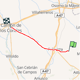

Length
24 km

Max alt
851 m

Uphill gradient
204 m
Km-Effort
27 km

Min alt
773 m

Downhill gradient
157 m
Boucle
No
Creation date :
2015-08-25 00:00:00.0
Updated on :
2015-08-25 00:00:00.0
--
Difficulty : Unknown

FREE GPS app for hiking
 SityTrail
IGN / Geographical institutes
SityTrail Plus
The world is yours!
About
Trail Walking of 24 km to be discovered at Castile and León, Unknown, Boadilla del Camino. This trail is proposed by Institut Géographique National.
Positioning
Country:
Spain
Region :
Castile and León
Department/Province :
Unknown
Municipality :
Boadilla del Camino
Location:
Unknown
Start:(Dec)
Start:(UTM)
388882 ; 4679594 (30T) N.
Comments